-40%
Early American History Map Home Schooling Teacher Travel Wall Art 11"x14" Print
$ 6.6
- Description
- Size Guide
Description
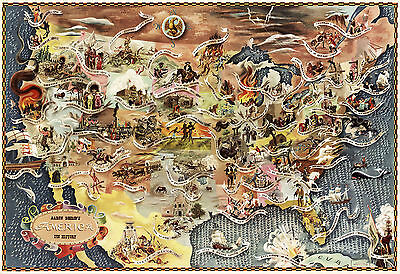
Aaron Bohrod's America It's History MapDetailed Specifications
This is a reproduction of the original map
Map Size: 11"x16"
This Map Comes in other Sizes too:
16"x23" and 23"x33"
You can find them and more
Maps of the United States
in
Our Store
We have more
Pictorial Maps
in
Our Store
All Our Posters and Maps Are Made in the USA
This 1946 map shows events from America's history for almost every state, showing all the greats from early American Folklore, with names of historical events.
Some examples:
The Mayflower, 1620 (Massachusetts)
Salem witchcraft, 1692 (Massachusetts)
Benjamin Franklin, 1706–1790 (Pennsylvania)
Battle of Quebec, 1759 (Canada)
Boston Tea Party, 1773 (Massachusetts)
Declaration of Independence, 1776 (Pennsylvania)
Surrender at Yorktown, 1781 (Virginia)
Underground Railroad, 1800s (from South to North)
Battle of Lake Erie, 1813
Columbus — Watling Island, 1492 (Bahamas)
Ponce de León, 1513 (Florida)
The Confederacy, 1861 (Alabama)
General Sherman, 1864 (Georgia)
Ku Klux Klan, 1866 (Alabama/Georgia)
Wright Brothers, 1903 (North Carolina)
Mark Twain's Mississippi, 1850s–1900s (along the Mississippi River)
Minnesota Sioux War, 1862 (Minnesota)
Wild Bill Hickok, 1860s–1870s (South Dakota)
The Great Chicago Fire, 1871 (Illinois)
Gold — Black Hills, 1874 (South Dakota)
The Alamo, 1836 (Texas)
Pony Express, 1860 (Nevada)
Geronimo, 1885 (Nevada)
Lewis and Clark Expedition, 1804–1806 (throughout the West)
Central and Union Pacific, 1869 (the West/Utah)
General Custer's Last Stand, 1876 (Montana)
San Francisco earthquake and fire, 1906 (California)
We have more maps in
Our Store
This map comes with a white border around the image
---------------------------
-How are the prints shipped?
They are rolled and placed into a rigid tube.
-Is this available in a larger/smaller size.
Yes. For smaller or larger sizes, email us.
